Heavy rain on the way as Met Éireann issues Status Yellow warning for Cork
You’ll be needing a decent raincoat this week.
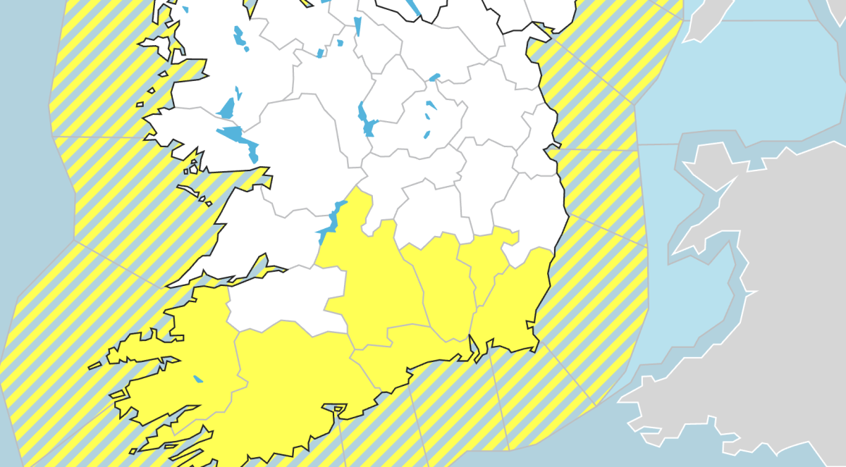
Met Éireann has issued a Status Yellow – Rain warning for Cork, Kerry, Wexford, Waterford, Carlow, Kilkenny, and Tipperary, with more heavy rain expected to fall on already saturated ground in the coming days.
Possible impacts include localised flooding and difficult travel conditions from 9pm on Monday to 9am on Tuesday.
A Status Yellow Wind warning is also in place for the entire country, with very strong and gusty southerly winds with gales possible near coasts and increased flood risk in coastal areas.
It’s shaping up to be a very wet night across the county, with persistent downpours that’ll be heavy at times. Winds are cranking up too, turning very strong and gusty as the night goes on.
We are closely monitoring a developing Atlantic system, potentially bringing very strong winds, high coastal water levels & heavy rainfall to Ireland from late tomorrow night 8th Dec through Tues 9th Dec.
➡️See our meteorologist’s commentary for details:https://t.co/gjN9OKe13m pic.twitter.com/49snC8Lsf0
— Met Éireann (@MetEireann) December 7, 2025
Temperatures won’t feel too wintry though, staying mild at 9–11 degrees and actually rising overnight.
Expect a very windy day on Tuesday. Rain will be fairly widespread early on, but should ease off and break up as it pushes north. By late afternoon, most places will see a mix of scattered showers and brighter spells.
It’ll be mild again, with temps of 13–15 degrees.
The rest of the week is a bit of a mixed bag — no big surprise there.
Tuesday night:
Rain clears the north, leaving many spots dry and clear, though western counties will still see scattered showers. Breezy, with lows of 6–9 degrees.
Wednesday:
Some uncertainty in the details, but likely a breezy day with showers and sunny spells. The south and east get the best of the bright, dry moments. Highs of 9–12 degrees.
Wednesday night:
Windy and mostly dry for a time, before rain moves into the west towards morning. Lows of 8–10 degrees.
Thursday:
Timing is still a bit iffy, but a band of rain is expected to move east across the country. Drier conditions follow, though Atlantic counties will continue to see showers. Windy early, easing later. Highs of 9–12 degrees.
Friday:
Breezy, bright and largely dry—except along Atlantic coasts, where showers could turn heavy with a chance of hail. Highs of 7–11 degrees.
Further outlook:
The Atlantic keeps things lively: more showers, more rain bands, some sunshine in between, and staying on the mild side for this time of year.